| iss-transit debuted on SourceForge on January 9, 2003 |
Deutsch Español Français Italiano Portuguese

31 March 2007
Ed Morana has developed a Java Based
Application which allows users to generate their own ISS transit
predictions. Details can be found on Ed's web site.
1 Jun 2005
Presently my server is busted, so I'm unable to generate new reports. I was trying to upgrade from Red Hat Linux 9 to Red Hat Fedora Core 3, and it didn't work out...
Fedora 4 will be released June 6, and I'll rebuild using that. At the same time, I'm upgrading from Oracle 9i to 10g, and installing WebLogic server software. I can't say right now how long all that will take, but I hope to have it all working again before the shuttle is launched.
Unfortunately I also may have lost some of my subscribers' database records (including their email addresses), so it may be necessary for some people to re-enter their
information.
Introduction to & summary of the project
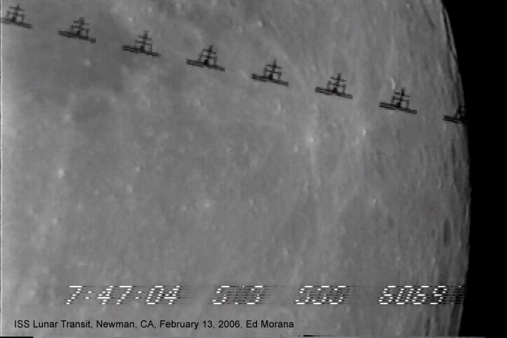
The Oct. 24, 2001, photo above, taken from Spartanburg, SC (34.9º N, 81.9º W), is a 16 second time-exposure made by my Kodak DC290 of the International Space Station passing across the face of a half-full moon (due to the long exposure, it gives the impression of being full), with Mars to the right. Unfortunately, the photo was flawed due to some settling of the tripod. thomasfly.com/spacestation has 2 other photos, taken before and after the above, as well as various ISS and weather related links.
This observation was largely due to luck. Using liftoff.msfc.nasa.gov/RealTime/JPass/25/JPass.asp, I'd determined that a flyover would occur that evening; but I was unprepared to see the ISS "shoot the moon!" Shown below is a screen capture of the Java applet on that page, showing the ISS passing in front of the moon at about 10:43 PM EST on 16 Jan 2003 (3:43 AM UTC 17 Jan 2003), viewed from 34.422º N, 81.578º W (.001º of a great circle = .07 mi / 365 ft / 111 m):

(Note: the size of the moon is exaggerated in this graphic, so it can't really be used to accurately determine transit passages.)
Running the applet using my present location, I saw that the ISS should pass a bit to the southeast of the moon. So I tried positions south and east of my location, including the above. The NASA applet now tells me where... weather permitting... a transit can be observed nearby.
"Nearby" is a relative term, of course: Microsoft Streets & Trips 2001 tells me I'll have to drive 46.7 miles (one-way) to observe this transit (1º of an average great-circle on the earth's surface is 69-1/6 miles). And then, since the ISS orbits about 242 miles / 387 km above the earth, being 1.06 miles off the transit path is the difference between witnessing a dead-center transit, versus a near-miss... or perhaps seeing nothing at all, if the ISS is too dim.

The orbital velocity of satellites in what's considered "low earth orbit" is about 5 miles per second; the ISS will therefore traverse the distance represented by the red arrow in about 7 seconds.
From the predicted time of the transit, and the moon's position in the sky (nearly overhead), one can infer that the moon should be nearly full that night. According to John Walker's Earth and Moon Viewer, it should look like this:

There are various complications & caveats connected with this problem, which are discussed in T.S. Kelso's Dec. 2000 Satellite Times article Tracking the Sun and the Moon. (see the last section, "An Interesting New Application"). In the J-Pass screen image above, the purple track indicates- as can be inferred from the fact that the flyover happens well after sunset- that the space station will not be sunlit, and hence it may not be visible at all, except for the 0.4 seconds that it will take to traverse the face of the moon! The same situation applies to transits of the sun; you will have to know exactly where to go to see the transit, and you'll have to know exactly when to be looking!
I subscribe to a service (available through the J-Pass URL) that sends me an email each week that the ISS can be sighted from my area, along with the basic viewing information:
|
||||||||||||||||||||||||||||||||||||||||||||||||||||||||||||||||
Unfortunately, the flyover given for 13 January is much too close to sunrise (only 20 minutes before) really to be visible; typically, you need a margin of 45 minutes before sunrise - after that, the sky will begin to brighten (similarly, you need 45 minutes after sunset). In fact, at higher latitudes, you will need a bit more of a margin, while at lower latitudes, you can get by with a bit less (at the earth's equator the sun sets "straight down," relative to the horizon, resulting in a minimum of twilight). Sunrise & sunset may be determined for your location using my Java applet:
This Java applet is also available as an application program, both for simple
download, or- better yet- as a ![]() application (which automatically downloads any new version). The
application version retains the last latitude & longitude used, so you don't
have to type it in each time. See thomasfly.com/Sunrise
for more information.
application (which automatically downloads any new version). The
application version retains the last latitude & longitude used, so you don't
have to type it in each time. See thomasfly.com/Sunrise
for more information.
Ultimately, it should be a goal of this project to offer a service for transit prediction that's similar to the NASA service for alerting subscribers to flyovers.
27 Apr 2003
I was able to obtain an "historic" tracking element from the NASA/GSFC Orbital Information Group for 24 October 2001:
1 25544U 98067A   01297.91564225  .00057028  00000-0  74292-3 0 06450
2 25544 051.6372 156.2244 0008628 241.1738 201.4785 15.58129277167323
Using that information, I'd have generated the following email alert:
        name: Thomas Fly
    latitude: 34.916 N
   longitude: 81.884 W
   elevation: 820 ft
alert radius: 30 mi
   time zone: -4.0
  last alert: 16 Jun 2003 | 16:00:41

During the current reporting period:
  there is no sun transit predicted within 100 miles
  minimum moon transit distance: 2.1 mi

A - travel distance (miles) and direction
B - date
C - time
D - elevation angle of the ISS
E - azimuth angle of the ISS (positive = east from north; negative = west from north)
F - range (miles)
G - latitude for observing the transit
H - longitude
I - how far (miles) can I be from the centerline?
J - is space station sunlit?
K - sun elevation angle
L - sun/moon separation angle
                                                                  LUNAR TRANSIT
A------- B----- C-----  D--- E----- F--- G------- H-------- I---- J K---- L----
 27.6 NW 24 Oct 194537  33.0  172.1  424  35.1975  -82.2290   2.6 y -13.5  99.5
 22.6 NW 24 Oct 194538  33.0  172.2  424  35.1426  -82.1710   2.5 y -13.5  99.5
 17.6 NW 24 Oct 194539  33.1  172.3  423  35.0877  -82.1130   2.5 y -13.6  99.5
 12.6 NW 24 Oct 194540  33.1  172.3  422  35.0328  -82.0552   2.5 y -13.6  99.5
  7.7 NW 24 Oct 194541  33.2  172.4  422  34.9779  -81.9974   2.5 y -13.7  99.5
  3.2 W  24 Oct 194542  33.3  172.5  421  34.9231  -81.9398   2.5 y -13.7  99.5
  2.1 SW            42.49                 34.8964  -81.9117   2.5
  3.3 S  24 Oct 194543  33.3  172.5  421  34.8682  -81.8822   2.5 y -13.8  99.5
  7.9 SE 24 Oct 194544  33.4  172.6  420  34.8133  -81.8247   2.5 y -13.8  99.5
 12.8 SE 24 Oct 194545  33.4  172.6  419  34.7584  -81.7673   2.5 y -13.8  99.5
 17.7 SE 24 Oct 194546  33.5  172.7  419  34.7036  -81.7100   2.5 y -13.9  99.5
 22.7 SE 24 Oct 194547  33.6  172.8  418  34.6487  -81.6528   2.5 y -13.9  99.5
 27.7 SE 24 Oct 194548  33.6  172.8  418  34.5939  -81.5957   2.5 y -14.0  99.5
Below, I used Microsoft Streets & Trips 2002 to plot the transit track:
![]()
"Field I" tells me that I can be as much as 2.5 miles off the center line (the blue line) and still see the space station cross some part of the moon- along the blue line, the ISS should go right across the center of the moon (i.e., traverse a full diameter).
The red lines, drawn on either side of the blue, are 2.5 miles from the center line; apparently, I was about 2 miles off this computed center line, according to S&T's measuring tool, as well as WorldView's computations ("Field A," rounded to the nearest tenth of a mile). At the time- I was a bit excited!- I had the impression that the ISS flew "dead-center" across the face of the moon; apparently it only barely transited the lunar disk, however.
One thing that's fairly certain is that my camera clock was off by about 4 minutes!
Below is the output from Rob Matson's SkyMap 6.6, using the center line location for 19:45:42.49 (I've added in a rough depiction of what the ISS would have looked like, from a distance of 421 miles):
![]()
From the location where the photos were taken, SkyMap indicates the following track across the moon's disk:
![]()
And here are plots of 3 recent transit observations:
In the last plot, the green line corresponds to the coordinates that would result if the observation had been made at sea level (green line), rather than an elevation of 900 feet (the sun was at an elevation of about 57° at the time). One way to look at it is to imagine that the transit track ran along the ridge line of a 57° steep, 900 ft high plateau; someone at the top of the plateau would be nearer the ISS, while making basically the same observation as a person at the base of the plateau.
And I've saved the best for last! Below are composite images of transits photographed by subscribers (click on the photos to go to their web pages):

Above: a rare color photograph of a transit by the International Space Station, 2004-06-08

And a Bull's-eye from 545 miles! ...
(predicted 3 days in advance by WorldView)

Below, a couple photos of ISS "planetary encounters," including another remarkable Bull's-eye!


... and Torsten Edelmann's spectacular ISS Saturn encounter,
of 1 April '04:
(substantial image-processing techniques were required to produce this final
result)
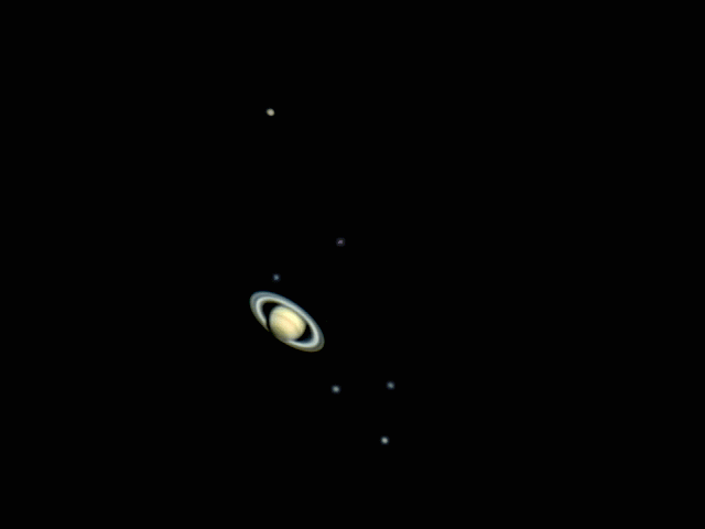
The distance to the ISS is 269 mi / 433 km; unfortunately, the main solar panels are edge-on, and so not visible,
... below, Mike Tyrrell and Phil Masding used their ISS VRML simulator to depict the ISS's 3D orientation in Torsten's video:

A "briefer than brief" history of ISS Transit ...
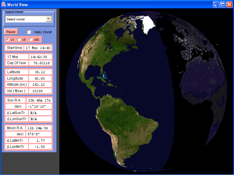
To some extent, I wanted an excuse to fool around with the Java 3D API; however, except for that initial effort, I've focused on adding features (not to mention accuracy!) to the email/online transit reports. The open source WorldView software currently is mostly "Oh, wow!" stuff. Eventually, I (and any qualified suckers that may volunteer to join the project) may turn it into something useful, for example, that will allow people to generate their own updates, as new tracking data becomes available.
But still, I think the 3D mode of WorldView is pretty cool ...
Below is my favorite photo of the International Space Station (you can click on the photo, below, to go to the Shuttle mission page that the photo is from). It makes me think they should have named the space station Magellan (although Magellan himself didn't make it all the way around the world), or perhaps the Victoria (the only ship of Magellan's that made it back to Spain), since it reminds me of nothing so much as a sailing ship of old, exploring uncharted oceans. Only this "sailing ship" circumnavigates the world every 92 minutes, compared to the 3 years it took the Victoria, 500 years ago. If the Victoria had been continuously circling the world every 3 years, since 1519, it would have completed 161 trips by now; the space station has circled the earth about 25,250 times since November 20, 1998!

SourceForge project page
ISS Transit
email-alert signup page (alternative
URL)
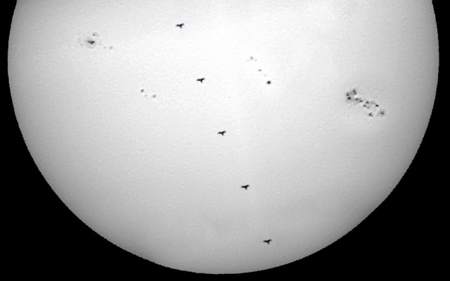
Simultaneous solar transits of the ISS and Venus,
8 Jun '04
Project Goals & Stuff ToDo
Links & Informational Resources
Released Software
page accesses
Tom Fly
10 Jan 2003 - updated 11 Apr 2004
You should enter something for an email address- if only :^) or a period or something- or the message will post as "anonymous."
You can use HTML including <img src=" http://thomasfly.com/spacestation/photo.jpg" width="150" height="101" alt="Market Restaurant- Fisherman's Wharf, San Francisco"><p>First footprints in the snow!</p> for example, but currently it doesn't like long URLs (such as http://www.photo.net/photo/pcd0942/george-alone-19.1.jpg) that don't all fit on a single line of the comment entry box.
If you want to bother with formatting, put a <hr> (horizontal line) at the beginning, and begin new paragraphs with <p> (you don't need to terminate them with </p>); to start a new line (as opposed to a new paragraph), end the line with <br>. (You'd think the <pre> "preformatted" tag would work, but it doesn't entirely...)
Finally, it's best to use the Comment button just below, rather than the one at the end.

